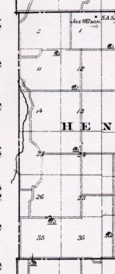
Map copied from Illustrated Historical Atlas of the State of Indiana, Baskin, Forster & Co, Chicago, 1876
| 6 | 5 | 4 | 3 Johnson Co | 2 Whitesides Roe Webb Porter Lamar Sch Dist #6 | 1 Wilson Sandefur Roe White Cutsinger 7
| 8
| 9
| 10 Johnson Co
| 11 Porter Whitesides | Lamar Strickler Reese 12 White Lamar | Webb Tucker Stroub Goff Treon Thurston 18
| 17
| 16
| 15 Johnson Co
| 14 Clark Beard | Tucker McCue Kimball Tucker 13 Tucker White | Gill Fogel Shaw Farmer Babb 19
| 20
| 21
| 22 Johnson Co
| 23 Scott Bass | Tucker Chappelow Fisher 24 Jacobs Tucker | Pottinger Williams Reese Tucker 30
| 29
| 28
| 27 Johnson Co
| 26
| 25
| 31
| 32
| 33
| 34 Johnson Co
| 35
| 36
| |
The above table is for a general overview of the neighborhood. For an exact description of the location and amount of land owned by each individual, please click on the individual section number (1-36) in the above table.
insert applicable township map links here