Shelby County, Indiana
Land Records
Township 12 North of Range 7 East
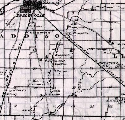
Map copied from Illustrated Historical Atlas of the State of Indiana, Baskin, Forster & Co, Chicago, 1876
This map was drawn before Addison Twp was divided into northern (Addison) and
southern sections (present-day Shelby Twp). The six eastern-most sections are in
Liberty Twp. Sec 2-11 are in Addison Twp. Sec 14-23 and 26-35 are in Shelby Twp.
Plat maps of adjoining lands:Land Records
Township 12 North of Range 7 East
Map copied from Illustrated Historical Atlas of the State of Indiana, Baskin, Forster & Co, Chicago, 1876
This map was drawn before Addison Twp was divided into northern (Addison) and
southern sections (present-day Shelby Twp). The six eastern-most sections are in
Liberty Twp. Sec 2-11 are in Addison Twp. Sec 14-23 and 26-35 are in Shelby Twp.
| 6 Shelbyville Sherer Kippers Downing Roe Alldridge Stillwell | 5
Shelbyville Hendricks Williams Young Hendricks | 4 Kelsey
Gatewood Severance Carnell Hendricks Youtsey | 3 Donnell
Walker Midkiff Lefever Bivans | 2 Donnell
Crane Cherry Titus Robertson | 1 Fisher
Allen Crane Lefton Midkiff Beggs |
| 7
Butler Shank Andrews Lemasters Robertson Veach Woods | 8 Tiller
Cummins Tingley French Jones Morris Walker Wortman | 9
Fisher Yeltin VanScyoc Shryock Rodefer Mayhew Chittenden Fisher | 10
Scott Newton Vanscyoc Smith Newton Bivens | 11 Louden
Kelly Newton Montgomery Louden Zell | 12
Palmer Akers Cromwell John Zell Beggs Jenkins |
| 18 Gaw
Allred Baker Butler Floyd Rowland Shank Wood | 17 Tingley
Fisher Springer Bulter Palton Morris | 16
School Commission Lands | 15 Ripple
Scott Higgins Wheeler Cherry Jones Jones | 14
Hosley Jones Wheeler Newton Laws Thralls Worland | 13 Laws
Simms Keck Palmer Newton Worland |
| 19 Maple
Troxell Mayhew Shank Case Case Shank | 20
Springer
Green Fleming Lennox Limpus Morris | 21 Fisher
Clark Gerard Mayhew Updegraff Lennox | 22 Sefton
Wheeler Graffort Cotton Green Green Major | 23
Prescott Cooper Sefton Peck Angelton Wheeler Newton Worland | 24 Orcutt
Crigler Burns Courter Peek Garey Robertson |
| 30
Eads Stuck Eads Baker Allred Andress McCarty Marcus Fenns | 29 Limpus
Morris Limpus Johnson Morris | 28 Morris
Lanham County Poor Farm Litteral McCann Morris Young | 27 Green
Fisher Copeland Garrison Young Morgan | 26 Corwin
Brown Bainam Corwin Garrison Johnson | 25 Peek
Stephens Vanpelt Brown Crisler McKinzey Price |
| 31 Stuck
Bedinger Fenn Wilson Andress Lanham McCurkel Stafford Springer | 32
Tingley Mahan Limpus Springer Stafford Springer | 33 Green
Fisher Mortimer Coleman Sidebottoms Allen Hendricks Matinley Wilson's Corner | 34
Baker Wood Hughbanks Green Copeland Baker Fisher Green | 35
Crigler Powel* Lanham Campbell Crisler | 36 Peck
Casto Mings Bless Jones Powell McKinzey Stafford |
* Also spelled Powell
The above table is for a general overview of the neighborhood. For an exact description of the location and amount of land owned by each individual, please click on the individual section number (1-36) in the above table.
Plat map of the owners in 1900 (T12N R7E)
North - T13N R7E
East - T12N R8E
South - T11N R7E
West - T12N R6E
 Land Records Index
Main Page
Land Records Index
Main Page