Courthouse Records
Land Purchases
Township 14 North of Range 7 East
1859
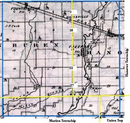
Map copied from Illustrated Historical Atlas of the State of Indiana, Baskin, Forster & Co, Chicago, 1876
Once the eastern half of (the original) Hanover Twp, this area is now
Van Buren (west), Hanover (east), Marion and Union ( far southeast) townships.
Present day township lines are marked in yellow above. Present day county roads
bounding this area are (clockwise) 1200 N, 500 E, 600 N and 100 W.
SR 9, not shown above, runs north and south from Shelbyville to Greenfield, east of Fountaintown.
Assessor's Ledger 1859, Hanover Twp
Sections 1, 2, 11, 12, 13, 14, 23, 24, 25, 26 and eastern half of 3, 10, 15, 22, 27
| 6 | 5
Fountaintown | 4 | 3 Bennett Bennett | 2 Bennett Bennett | 1
Morristown Bentley&Holoway Blevin |
| 7 | 8 | 9 | 10 | 11 Gelletsburg Bennett | 12 |
| 18 | 17 | 16 | 15
Freeport Adams | 14 Freeport Adams Blevin | 13 |
| 19 | 20 | 21 | 22 | 23 Butler Hanover Cemetery | 24 Butler Buck |
| 30
| 29 | 28 | 27
Alexander Cory Colglazier | 26 | 25 |
| 31 | 32 | 33 | 34 | 35 | 36 |
and amount of land owned by each individual, click on the individual section number (1-36) above.
