Shelby County, Indiana
Land Records
Township 14 North of Range 8 East
Map copied from Illustrated Historical Atlas of the State of Indiana, Baskin, Forster & Co, Chicago, 1876
The yellow lines mark the present day townships - Hanover (north) and Union (south). U.S. Highway 52 runs northwest from Rushville to Indianapolis. The bottom blue line represents County Road 600 North; the top would be 1200N. The left blue line represents County Road 500E; the right is 800E.
Original purchases from the United States Government
The above table is a general overview of the neighborhood. If the section number is underlined in the table, you can click on the number for an exact description of the location, amount of land purchased and the residence of the individual at the time of purchase. All other records are available at the Recorder's Office.
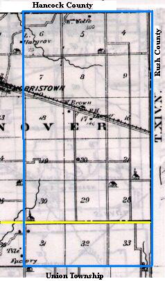
Land Records
Township 14 North of Range 8 East
Map copied from Illustrated Historical Atlas of the State of Indiana, Baskin, Forster & Co, Chicago, 1876
The yellow lines mark the present day townships - Hanover (north) and Union (south). U.S. Highway 52 runs northwest from Rushville to Indianapolis. The bottom blue line represents County Road 600 North; the top would be 1200N. The left blue line represents County Road 500E; the right is 800E.
Original purchases from the United States Government
| 6 Smith Tyner Smith Nash Rees | 5 Tyner Handy Wolf Handy Keaton Katen Wilson | 4 Silvester Parkes Boatright Nicholson Owings/Owens Kennedy Lee Snider Scott | 3 Rush Co | 2 | 1
| 7 Keaton Keaten | Keaten Francis Tolle Francis Rees 8 Keaton Ennis | Cunningham Messersmith Moffitt Wilson Messersmith 9 Lee Baity | Stephens Moore Stapleton Stephens Keaton 10 Rush Co
| 11
| 12
| 18 Francis Johnson | Spurrier Tolle Williams Gordon 17 Stone Fielding | Johnson Hunter Buck McConnell McConnell Moffitt 16 School Commission Lands
| 15 Rush Co
| 14
| 13
| 19 Pollitt Buck | Hurst Montgomery Darmer Williams 20 Buck Green | Kensler Ludlow Saxon Davis Philpott 21 Macy Barnard | McConnell McConnell Stephens 22 Rush Co
| 23
| 24
| 30 Bennett Carmony | Carmony Montgomery Montgomery Ennis Thornberry Young 29 Saxon Stephens | Stephens Talbert Youngs Cook Smith Stephens Montgomery 28 Stephens Fields | Phares Hiatt Swain Poulding Stephens Leonard Griffin 27 Rush Co
| 26
| 25
| 31 Rhoades Booher | Talbert Thornberry Booher Rauzell Barnard 32 Jones Coffin | Jones Swain Cook Smith Stubbs Young Stubbs Barnard 33 Zike Coffin | Stanton Swain Swain Coffin Davis Davis 34 Rush Co
| 35
| 36
| |
The above table is a general overview of the neighborhood. If the section number is underlined in the table, you can click on the number for an exact description of the location, amount of land purchased and the residence of the individual at the time of purchase. All other records are available at the Recorder's Office.
Adjoining lands:
North, T15N R8E, Hancock Co, IN
East, Rush Co, (eastern half of) T13N R8E
South, T13N R8E
West, T14N R7E
 Land Records Index Main Page