1859
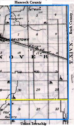
Map copied from Illustrated Historical Atlas of the State of Indiana, Baskin, Forster & Co, Chicago, 1876
The yellow lines mark the present day townships - Hanover (north) and Union (south). U.S. Highway 52 runs northwest from Rushville to Indianapolis. The bottom blue line represents County Road 600 North; the top would be 1200N. The left blue line represents County Road 500E; the right is 800E.
Assessor's Ledger, 1859
| 6 | 5 Ball | 4
Andis Addison Anderson Ball | 3 Rush Co | 2 | 1 | ||||||||||||||||||||||||
| 7 | 8 Burton | 9 Ball Burton Bundy | 10 Rush Co | 11 | 12
| 18
| 17 Brown
| 16 Baty
Babcock
| 15 Rush Co
| 14
| 13
| 19 Buck
| 20 Buck
| 21 Anderson
| 22 Rush Co
| 23
| 24
| 30
| 29 Ash
| 28
Ash
| 27 Rush Co
| 26
| 25
| 31
| 32
| 33
| 34 Rush Co
| 35
| 36
| |
The above table is a general overview of the neighborhood. If the section number is underlined in the table, you can click on the number for an exact description of the location, amount of land purchased and the residence of the individual at the time of purchase. All other records are available at the Recorder's Office.