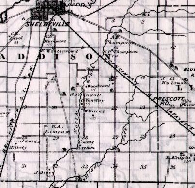
Map copied from Illustrated Historical Atlas of the State of Indiana, Baskin, Forster & Co, Chicago, 1876
This map was drawn before Addison Twp was divided into northern (Addison) and
southern sections (present-day Shelby Twp). The six eastern-most sections are in
Liberty Twp. Sec 2-11 are in Addison Twp. Sec 14-23 and 26-35 are in Shelby Twp.
1900 Plat Map
| 6 Shelbyville | 5 Shelbyville | 4 | 3 | 2 | 1
| 7
| 8
| 9
| 10
| 11
| 12
| 18 Knowlton Dodds | Lefferson Thompson Smith Vanpelt 17 Thompson Dugan | Schumacher Thompson Vanpelt Hamilton Tindall Stafford 16 Messick Amos | Sexson Limpus Limpus Vanway Terry Woodard 15 Jackson Debusk | Walker Zell Crawford Wheeler Wheeler Morrison 14 Pohlman Laws | Worland Miller Bernheimer Wheeler 13
| 19 Dill Hamilton | Hey Howe Cherry Scheffler Dugan Courtney Hey 20 Newton Coyle | Tindall Dunn Agner Carithers Tindall Courtney 21 Terry Limpus | Amos Thurston Main Clapp Green Young 22 Green Wheeler | Johns Crawford Bogeman Seigel Schoentrup Green 23 Crawford Lux | Bernheimer Wishard Zoble Heppner Prescott 24
| 30 Stephens Henry | McColley Swinford McCarty Fenns 29 Limpus Tindall | Tindall Miller Lamasters Hirschauer Major 28 Amos Clapp | Tindall Wilson Henricks County Poor Farm 27 Pond Worland | Trees Barnes Zoble Coleman Braunagel Young Coyle 26 Fischer Becker | Wiskers Firsich Zetlmeier Chapman Zoble Zoble 25
| 31 Eades Lee | Patterson Green McCarty Green Green 32 Green Green | Connor Coleman Green Green Crisler Lemaster 33 Henricks Conner | Hamilton Barnes Nugent Conner Gregory Conner 34 Lee Coyle | Hubanks Jackson Newton Leppert Monroe Lemaster 35 Monroe Leppert | Stafford Stickford Washburn Benson Monroe Coleman 36
| |
The above table is for a general overview of the neighborhood. For an exact description of the location and amount of land owned by each individual, please click on the individual section number (1-36) in the above table.
Plat map of the original government land patents (T12N R7E)