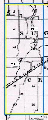
Map copied from Illustrated Historical Atlas of the State of Indiana, Baskin, Forster & Co, Chicago, 1876
The yellow lines mark the present day townships - the entire area is within Sugar Creek Township. The bottom blue line represents Range Road (00); the top would be 600N. The left blue line represents County Road xxxE; the right would be xxxE. Johnson Co is on the left/west; Moral Township is on the top/north; Hendricks Township is below/south.
Original purchases from the United States Government
| 6 | 5 | 4 | 3 | 2 Clark
Clark Hosier Adams River Power Imhoff Owens | 1
Hough Kerr Holton Blakeman Hough Mozingo Hough Fuller Tull | ||||||||||||||||||||||||
| 7 | 8 | 9 | 10 | 11
Morgan ?? Padrick Francis Spiegel Wall ?? Powers ?? ?? | 12 Finkley Francis Roarer Cox Hough Hough Hough Francis 18
| 17
| 16
| 15
| 14
Owens Hosier | Wayman ?? White White Gird ?? Carson White 13
White Morgan | McConnell Pedan Norris Collins Huff Carson Morgan 19
| 20
| 21
| 22
| 23
White Carson | McConnell McConnel McConnel 24
Carson Routt | Brison Conover Johnson Carson 30
| 29
| 28
| 27
| 26
Hadden Trisler | Trisler Rhorer White Metiere Hanson McConnell 25
?? Carson | McFadden Daniel Hadden Trister ?? Carson Woods 31
| 32
| 33
| 34
| 35
White Beard | Hoover Alexander Hoover Beard Webb Strickler McFadden 36
Rhorer Carson | McFadden Rhorer Strickler Williams Strickler Mock |
The above table is for a general overview of the neighborhood.
For an exact description of the location and amount of land owned by each individual,
please click on the individual section number (if highlighted) in the above table.