Shelby County Indiana
Land Records
Township 14 North of Range 5 East
Map copied from Illustrated Historical Atlas of the State of Indiana, Baskin, Forster & Co, Chicago, 1876
This is the far northwestern corner of Shelby Co. The entire area lies in Moral Twp. Hancock Co is on the northern border. Marion Co and Johnson Co are on the western border. Directly south is Sugar Creek Twp. Michigan Road runs northwest through Pleasant View.
Original purchases from the United States Government
The above table is for a general overview of the neighborhood. For an exact description of the location and amount of land owned by each individual, please click on the individual section number (if highlighted) in the above table.
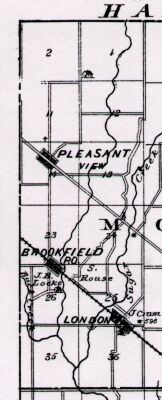
Land Records
Township 14 North of Range 5 East
Map copied from Illustrated Historical Atlas of the State of Indiana, Baskin, Forster & Co, Chicago, 1876
This is the far northwestern corner of Shelby Co. The entire area lies in Moral Twp. Hancock Co is on the northern border. Marion Co and Johnson Co are on the western border. Directly south is Sugar Creek Twp. Michigan Road runs northwest through Pleasant View.
Original purchases from the United States Government
| 6 | 5 | 4 | 3 Marion Co | 2 Williams Rouse Plummer Catterson Wilkins Parrish Fee Joyce Dennis Adams | 1 Means Rawlings Senior Means Wilkins Murnan Ware |
| 7 | 8 | 9 | 10 Marion Co | 11 Mann Hume Fee Pitcher Fee Means Fee Mann | 12 Joyce Fee Ware Amos Murnan Joyce Plummer Pollard |
| 18 | 17 | 16 | 15 Marion Co | 14 Keeler House Means Means Pleasant View Means Means Right | 13 Means Portlock Wilson Breedlove Stanley Wright Fee Gossett Means |
| 19 | 20 | 21 | 22 Marion Co | 23 Meanes Means Means Means Meanes Hibler | 24 Portlock Lines Fray Means Doble Cobb House Wright |
| 30 | 29 | 28 | 27 Johnson Co | 26 Poer Joyce Means Dearmin Kibler Kallam Yoke Means | 25 Killgore Fansler Farnsler Jackson Dake House London |
| 31 | 32 | 33 | 34 Johnson Co | 35 Yoke Huffer Farnsler Bowman Surber Means Yoke Huffer Dearmin | 36 Farnsler Wright Hause House Fansler Nichols Nichols Peddicord |
The above table is for a general overview of the neighborhood. For an exact description of the location and amount of land owned by each individual, please click on the individual section number (if highlighted) in the above table.
Maps of adjoining areas:
North, Hancock Co, IN
East, T14N R6E
South, T13N R5E
West, Marion and Johnson Co
 Land Records Index
Main Page
Land Records Index
Main Page