Shelby County Indiana
Land Records
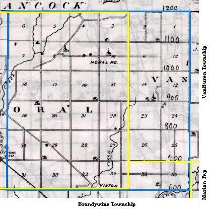
Township 14 North of Range 6 East
Map copied from Illustrated Historical Atlas of the State of Indiana, Baskin, Forster & Co, Chicago, 1876
Once the western half of (the original) Hanover Twp, this area is now Moral Twp and VanBuren Twp,
with the southern edge in Brandywine Twp and Marion Twp.
Present day township lines are marked in yellow above. Present day county roads
bounding this area are (clockwise) 1200 N, 100 W, 600 N and 700 W.
Original purchases from the United States Government
Land Records
Township 14 North of Range 6 East
Map copied from Illustrated Historical Atlas of the State of Indiana, Baskin, Forster & Co, Chicago, 1876
Once the western half of (the original) Hanover Twp, this area is now Moral Twp and VanBuren Twp,
with the southern edge in Brandywine Twp and Marion Twp.
Present day township lines are marked in yellow above. Present day county roads
bounding this area are (clockwise) 1200 N, 100 W, 600 N and 700 W.
Original purchases from the United States Government
| 6 Wilkins Manan Hutchinson Plummer Barnes Wilkins Joyce Manan Manan | 5 Thomas Manan Manan Harper Murnan Youtsey Youtsey Murnan | 4 Griffith Gregg Gregg Culbertson Rawlings Powell Gregg Nollenger | 3 Cones Hamilton Pye Caldwell Moore Smith Romrel* Tracy Nollener Campbell | 2 Herman Manan Plummer Dungan Dungan Bates Moore | 1 Gregg Hank Earl Flanagan Fox Fox Starrett 7 Wilkins Murnan | Manan Wilkins Plummer Culbertson Manan 8 Heart Reaves | Vernon Reeves Woodbury Amos Reaves Marshall 9 Ayres Amos | Amos Ruggles Woodbury Wilson Senior Asher 10 Tracy Ruggels | Ruggles Breedlove Moore Campbell Reeves Wilson 11 Moore Campbell | Reeves Amos Hittle Snodgrass Kepley 12 Rhodes | Johnson Johnson Johnson 18 Smith House | Johnson Breedlove Cones Means Sanders Wycoff House Smith 17 Burtch Grubbs | Lipscomb Lipscomb Jackson House Sanders 16 School Commission Lands
| 15 Vernon Wilson | Ruggles Hamilton Carmony Hodges Rhodes Conner 14 Arnold Hamilton | Boss Headlee Arnold Boss 13 Hamilton Johnson | Reeves Hamilton Totten Bollibaugh Kitchel 19 Peck Doble | Portlock Grubbs Doble House House House 20 Handley Means | Maholm Martin Coffey Wendt Maholm Means 21 Vice Portlock | Parsons Stapp Vice Mann Dunn Dunn Fisher 22 Bennett Parsons | Murphy Oldham Seney Kyle Ellis Hoover Howrey 23 Oldham Oldham | Oldham Roberds Wiggans Husky Boss Thomas Totten 24 Copple Bass | Kitchel Bass Wickliff Wickliff Totten Wickliff 30 Hoop Hoop | Holmes House House Holmes Hoop House 29 Walker Sparks | McCoy Holmes Hoop Morgan Johnston Handley Portlock 28 Kyle Griffin | Handley Johnston Kyle 27 Wilson Griffin | Hobbs Seney Ellis Seney Cartwright 26 Seney Thomas | Thomas Totten Seney Surber Joslin Summey Summey 25 Totten Debord | Oldham Alexander Totten Joslin Whited Bishop Hubbell Debord 31 House Sparks | Walker Walker Walker 32 Bennett McCoy | Andress Hodson Walker Morgan Barnell 33 Joslin Bush | Reveal West Seney Oldham Andrews Morgan Oldham 34 Lowe Bishop | Johnston Wilson Stump Cartwright Miller Matthews 35 Day Summey | Brady Day Bishop Debord Debord Harrell 36 Oldham Surber | Alexander Williams Williams Whited Alexander Oldham |
The above table is for a general overview of the neighborhood. For an exact description of the location
and amount of land owned by each individual, click on the individual section number (1-36) above.
* Spelled Romerill in early marriage records
Maps of adjoining areas:
North, T5N R6E, Hancock Co, IN
East, T14N R7E
South, T13N R6E
West, T14N R5E
 Land Records Index
Main Page
Land Records Index
Main Page